Great Supramonte Crossing
1.099,00 €
Great Supramonte Crossing
A unique hiking tour in the most characteristic mountains of Sardinia.
The Great Supramonte Crossing is a beautiful 4 days trekking that crosses lengthwise the natural park of Supramonte. The landscape changes continuously and panoramas are always remarkable. Starting from the southernmost edge, the trail passes through thick woods and open plateaus, up to the northernmost edge.
Supramonte is a vast massif made of limestone and as such, it is grooved with deep canyons, sinkholes and caves. Under the surface, an extended groundwater system of underground rivers, lakes, caves and endless passages collects and joins the water to some famous springs and other hidden locations.
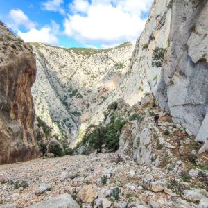
Above the ground, there are only a few dirt roads, so tortuous and rough that only 4WD can make it through. The only traces of human life are the rare refuges that charcoal burners and shepherds built during the past centuries. They used to move to Supramonte during the summer in search of pastures for their goats but slowly abandoned these lands since WW2. Local hikers are familiar with the harshness of Supramonte and approach its fascinating destinations with due prudence. It is very easy to get lost in the many forests and narrow canyons, and the terrain does not make rescue any easy.
If Supramonte is not a welcoming place for humans, it is the quiet and unspoiled home of animals such as deer, boars, goats, foxes, weasels and many more. The sky, on the other hand, is home for many birds of prey, hovering in circles in search of the occasional mouse or snake. The vegetation that covers it is the typical Mediterranean, from oak and juniper forests to vast fields of perfumed shrubs such as myrtle, lentiscus, helichrysum and many other flowering bushes.
The total length of the Great Trail of Supramonte is 53 km, with only gentle slopes well distributed over the 4 days.
After a meeting in Oliena and checking our bags and equipment, a transfer will drive us to the starting point.
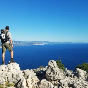
Our walk will start from the springs of the Flumineddu River, which cuts the mountains of Supramonte and created the enormous Gorroppu Gorge. Walking over the plateaus we will reach the characteristic tacchi (trans. "heels") mount Fumai and mount Su Biu. The path keeps an altitude included between 1000 and 1200 metres above sea level and the only ascent will occur to climb up the stairs to the top of Monte Novo S.Giovanni at 1316m. This is the most panoramic spot for the day and is only 1 hour away from the unattended hut where we will spend the night.
Meeting location: Oliena
Time: 9 am
Transfer: included (40 minutes drive)
Time: 6h
Length: 9km
Vertical gain: +470m
Passing through dense oak forests and open plateaus, our path becomes really fascinating with a continuous alternating of views. A little detour takes us to the remote Nuraghe Mereu, one of the masterpieces of the Nuragic civilization. Despite its 4000 years of age, the Nuraghe is still well preserved, and the location in which it was built is one of the most amazing in Sardinia. It oversees the mountains surrounding the Flumineddu River and the Gorroppu Gorge, possibly catching sight of invaders approaching the Supramonte.
Our day ends over the plateau Donanigoro, where we will set camp on the unattended hut Ziu Raffaele. The plateau is scattered with the rest of a Nuragic village, puzzling visitors about how life must have been here back then.
Time: 8h
Length: 19km
Vertical gain: +400m
From the plateau Donanigoro we will soon visit the enormous sinkhole Su Sercone, which measures almost 500 metres in diameter and 200 metres in depth. The path continues through a dense forest populated with secular oak trees and many abandoned shepherd huts. At the end of the forest, we will steer north, following the crest of mount Corrasi up to the top of Supramonte (1463 m), from where we will witness one incredible view. The panorama extends over the regions Goceano and Marghine, making it possible to spot towns as distant as 50 kilometres away.
From mount Corrasi we will walk down on a typical Campo Solcato (literally plough field), a limestone expanse ‘ploughed’ by rainwater. Not distant from this is the plateau Sos Prados with another unattended hut where we will spend the night.
Time: 8h
Lenght: 14km
Vertical gain +: 700m
We will reach the crest of mount Carabidda, which marks the northwest corner of the Supramonte and offers a superb panorama over the town of Oliena and the valleys below. From here we will steer eastward to follow the northern edge of Supramonte over the crest of mount Cusidore. Our itinerary goes downhill towards the bottom of the valley, descending from 1200 to 200 m at the end of our journey, by the renowned spring Su Gologone.
From Su Gologone a tansfer will drive us back to Oliena (15 minutes drive)
Arrival point: Su Gologone
Transfer: back to Oliena (15 minutes drive)
Tempo: 6h
Lunghezza: 10km
Dislivello +: 200m
Length
Total time
%
Physical effort
Great Supramonte Crossing, guided trekking tour
1.099,00 €
Meeting location and timing
- Meeting location: Oliena
- Meeting time: 9:00 am
- Estimated return to meeting point: approx 18:30
DETAILS
- Length: 48 km
- Total time: 4 days
- Difficulty: medium
EXCLUSIVE TOURS
To request a tour in exclusive for you please send us an email or call +39 3291547816
FREQUENTLY ASKED QUESTIONS
nascosto
How hard is this trekking tour?
The Great Supramonte Crossing is fairly hard, but accessible to anyone in good physical shape.
The trekking starts at an altitude of 1250 meters above sea level and will keep a similar altitude in the days to come. The path is easy and there are no major uphills or scree. On the last day of walking the path includes some hopping on rocks to descend to the end point, this anyhow can be skipped by passing on a lower track.
It is fundamental not to have irrational fears such as acrophobia or agoraphobia, and be ready for a challenge and get tired.
Are there any roads in Supramonte?
There are no roads crossing the mountains of Supramonte. There are only a few dirt roads on the southern side and over the western edge. We will see some sections of these dirt roads but will mostly walk on mountain paths.
In case of an emergency retreat, even if walking on a dirt road, it may take several hours to reach the main road. Towns are too far away to be reached in one day.
Therefore, escaping quickly requires a 4WD transfer to reach the nearest town.
What should I wear on the Great Supramonte Crossing?
You should wear comfortable clothes, appropriate to the season. It is fundamental to wear hiking shoes with a rigid sole.
In the summertime, it is best to wear a polyester t-shirt and shorts. Cotton shirts get wet and won’t dry out in time. The trekking lasts almost 5 hours trek (including return).
We recommend a soft-shell jacket as it is often windy.